

Geo Data Explorer App
by Tech Maven Geospatial, LLC
Ready for any data
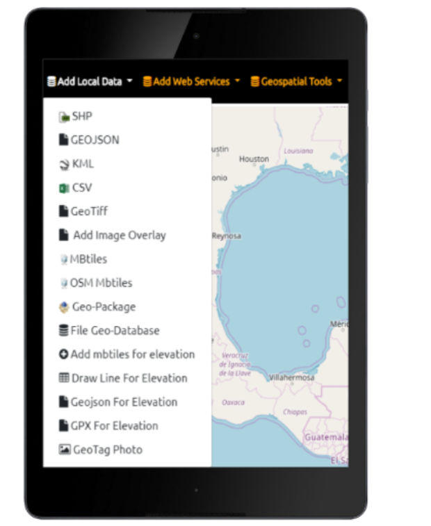
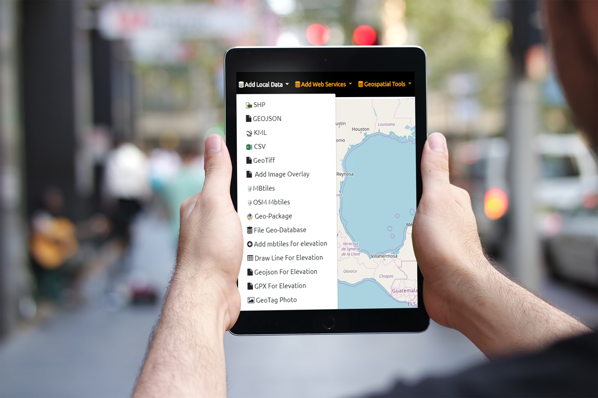
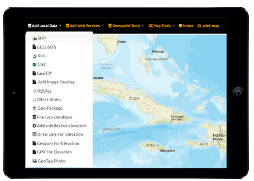
Easily view online Geospatial Data ESRI and OGC Mapping Services, File Based Formats, Draw and Edit Vector Data
GPS & IP Geolocation
Show your position, Show Coordinates Google Place Search and GeoCoding
Affordable
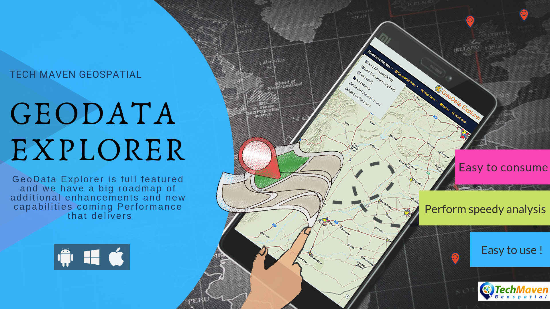
GeoData Explorer is full featured and we have a big roadmap of additional enhancements and new capabilities coming Performance that delivers. Vector Tile basemaps and overlays and transparency/opacity slider for data. Real time savings and enables more access to data
Jam Packed with Useful Features
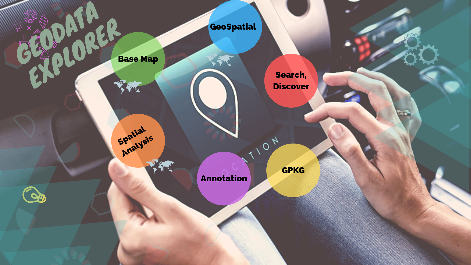
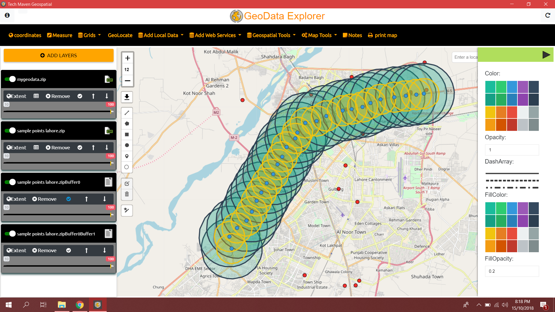
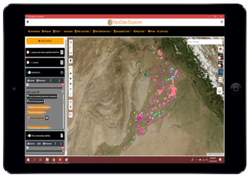
Easy to use ! Easy to consume/view/discover data and perform visualization, annotation, printing and analysis Perform speedy analysis like buffering, View different basemaps, view attribute table and export results

100’s of Features
Fast and Powerful Mapping Engine
We designed GeoData Explorer after using countless other mobile apps and being frustrated with their limited Geospatial Data format support, no attribute table viewing and lack of easy use and sometimes vendor lock-in. So we set out to engineer this product to meet our specifications and realized the benefit it would have to other users.

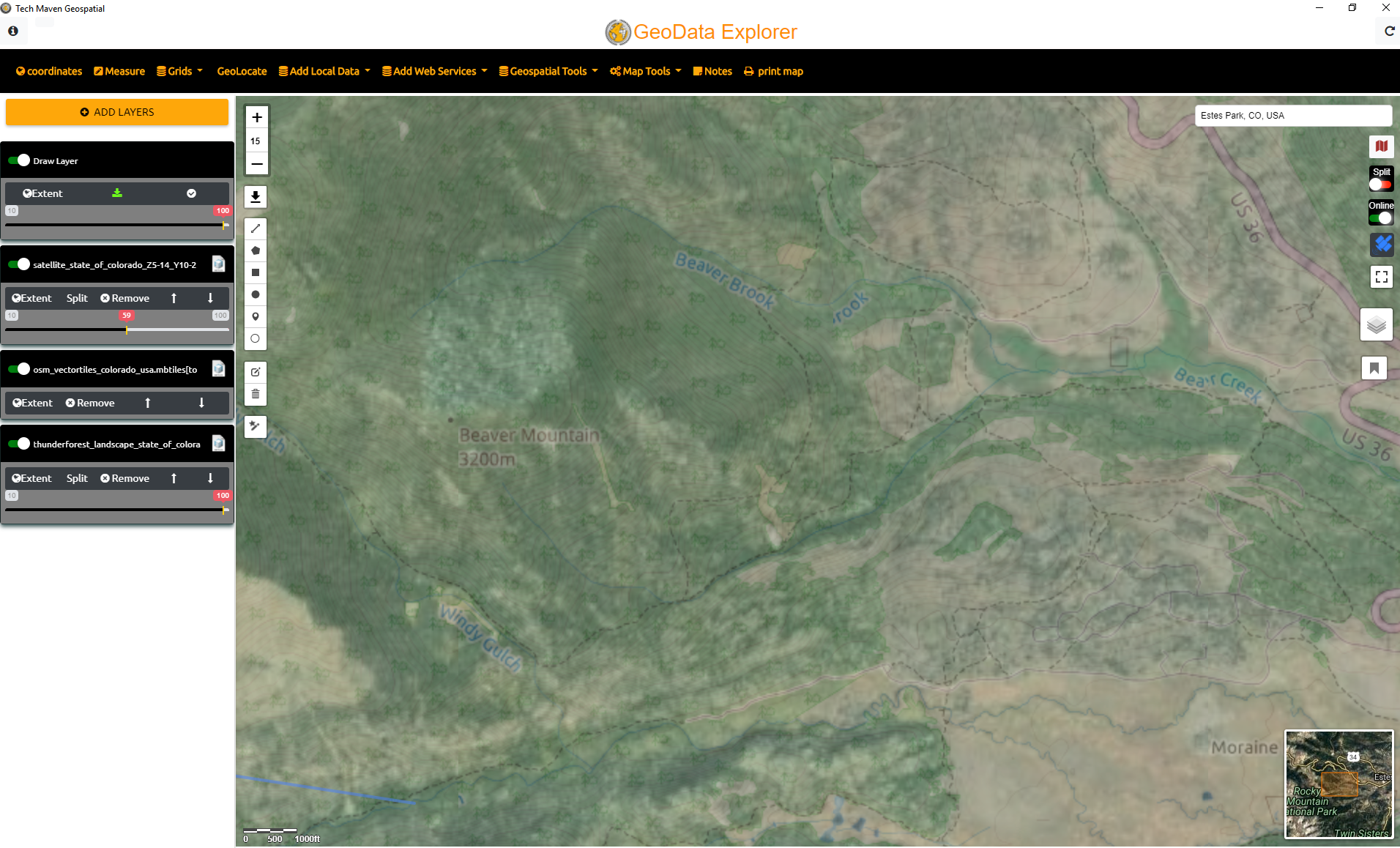
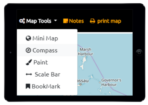
Map Viewing
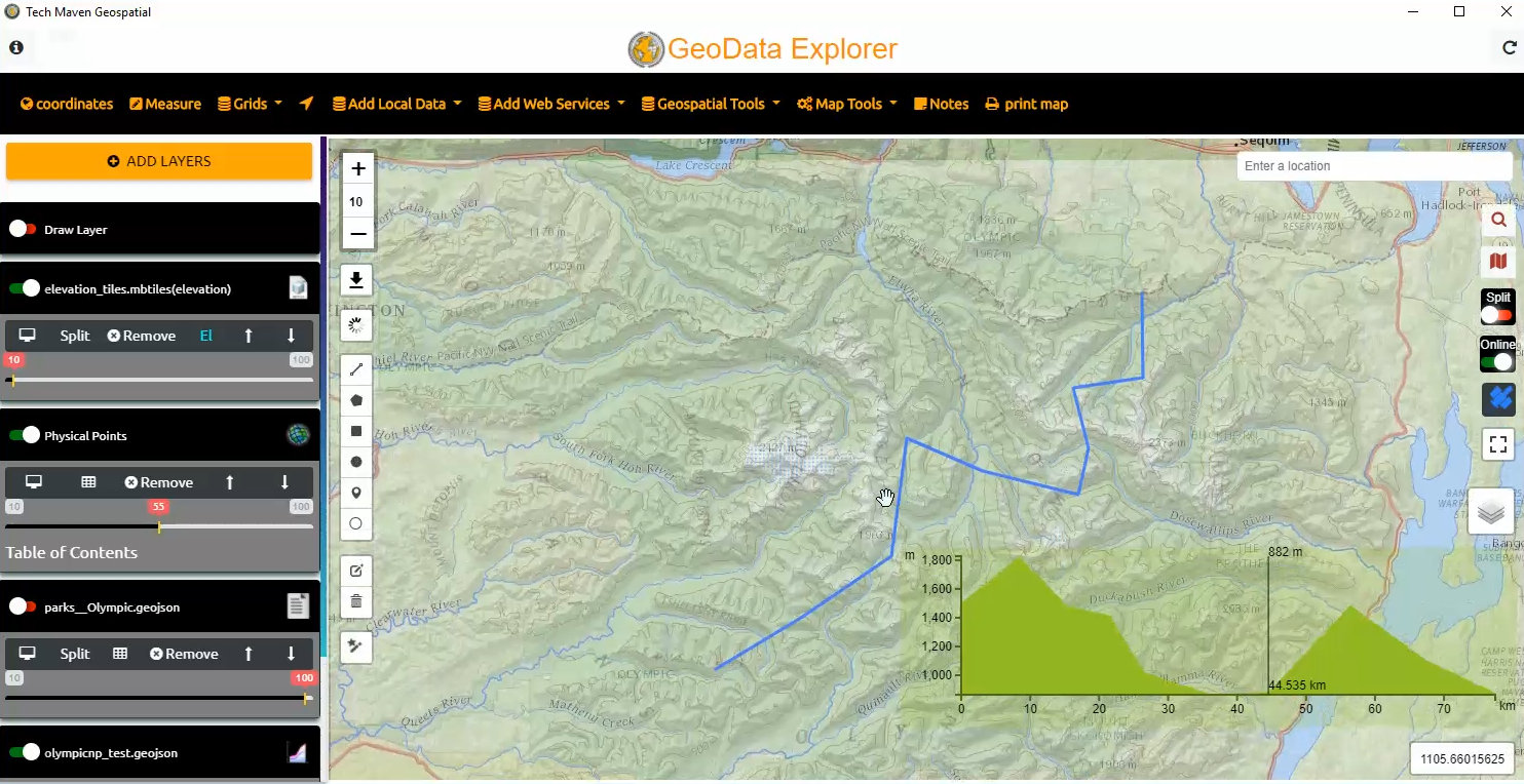
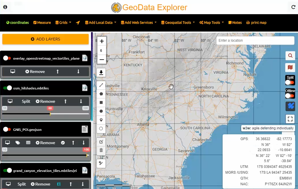
Configure different basemaps from our basemap picker or add a new one URL. Display Coordinates (GPS Lat Long, UTM, MGRS, USNG, Maidenhead) and Graticule Lines Our mapping engine is one of the fastest rendering of data you’ll find.
Offline/Disconnected Data
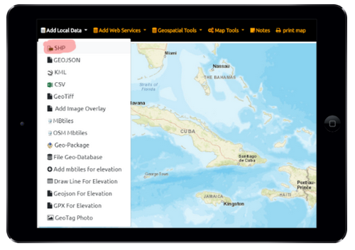
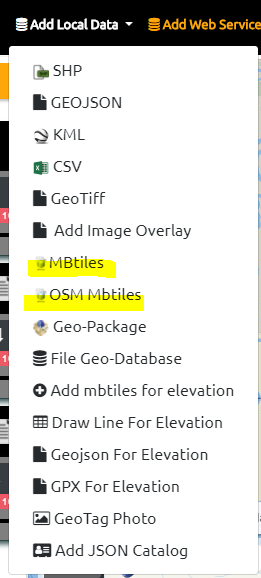
The app supports many formats of offline files and database. (Mbtiles, GeoPackage, Shapefiles, GeoJSON, KML)
Spot Elevation
Display Spot Elevation Values for anywhere with and without internet (when offline data is loaded)
We support MapZen Terrarium PNG Tiles Format from tile server and inside MBTILES. Display Terrain Profile view Graph (see the slope/steepness)
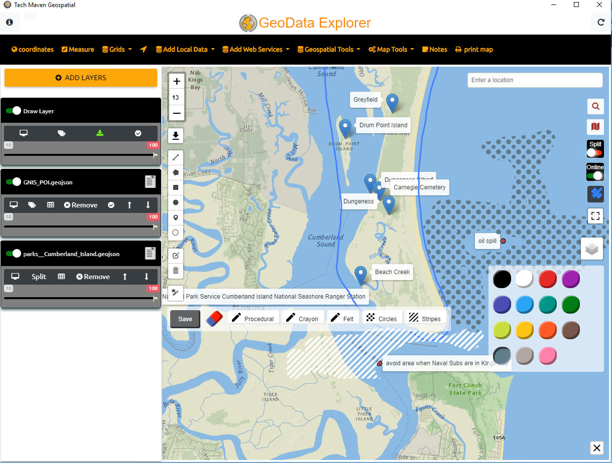
Draw features and assign attributes
Drop a point, Ciricle, Line, Polygon feature on the map and assign unlimited keys and values (attributes) to that location and save as GeoJSON (coming soon save as GPKG). Also, attach media to the location. Full styling control for symbology representation.
Your Position on Map
Show your position on the map via Geolocation Geolocation feature works with GNSS Receivers (GPS) or WiFi via IP Address. Display routes on the map as well. Display North Compass Arrow Display Coordinates in multiple formats
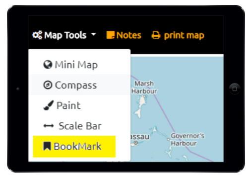
Spatial Bookmarks
Save map extent/location so you can easily come back to an area. Create unlimited spatial bookmarks
BaseMap Picker
Select Multiple Basemaps from open source and commercial providers. Google, Bing, ESRI, Stamen, Thunderforest, Open Street Map, HERE, CartoDB, NASA and others.
Annotation
Use Annotation Tools like crayon and marker and hatch patterns with color picker
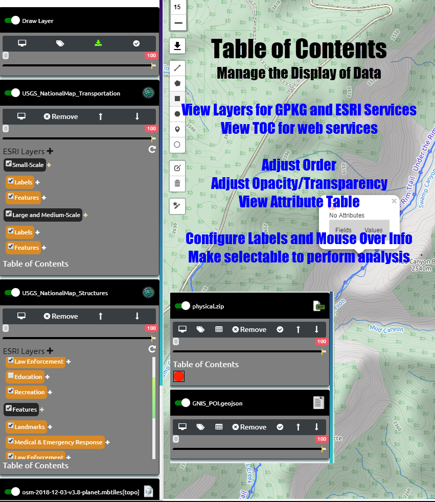
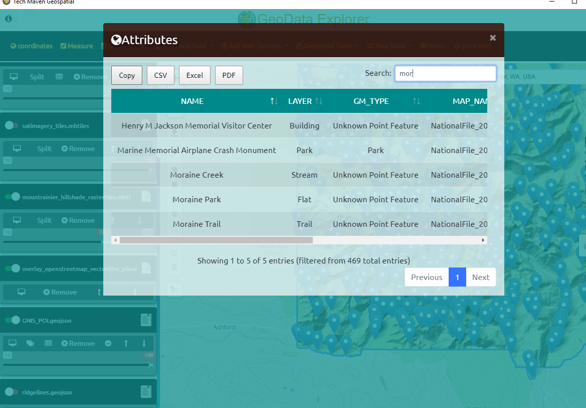
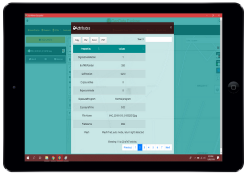
View Attribute Table
View attribute table and sort and filter
GeoPackage Support
We full support OGC GPKG – GeoPackage SQLite format for offline vector features and raster tiles and elevation tiles
Geospatial Analysis
Perform analysis and geoprocessing operations like Buffer, voronoi, center, envelop, convex, bounding box and other operations all offline with no server-side processing and include previous operations for chaining commands together
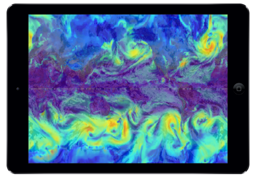
Weather
Show weather overlays like precipitation, clouds, snow, heat index and many other overlays
Display Grids
display reference graticule and gridlines and numbers Including Metric, Imperial,UTM and MGRS
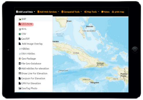
Catalog/Project Files
JSON Catalog Files and Catalog Editor
Vector Tiles
If you load a GeoJSON file the app will automatically split the file (up to 200mb) into tiles 256×256 pixels and different zoom levels for rapid display and rendering. We also support MapBox Vector Tiles (gzipped PBF) inside MBTiles or via an online XYZ Tile Server. We also support Open Street Map Vector Tiles with different stylesheets
Google Services Integration
Full Google Maps and Places Search and Routing/Directions
Swipe to compare maps
Use the Layer Swipe tool to easily compare datasets or basemaps
Labels
Label vector features & drawing layers
Also include mouseover instead of permanent label
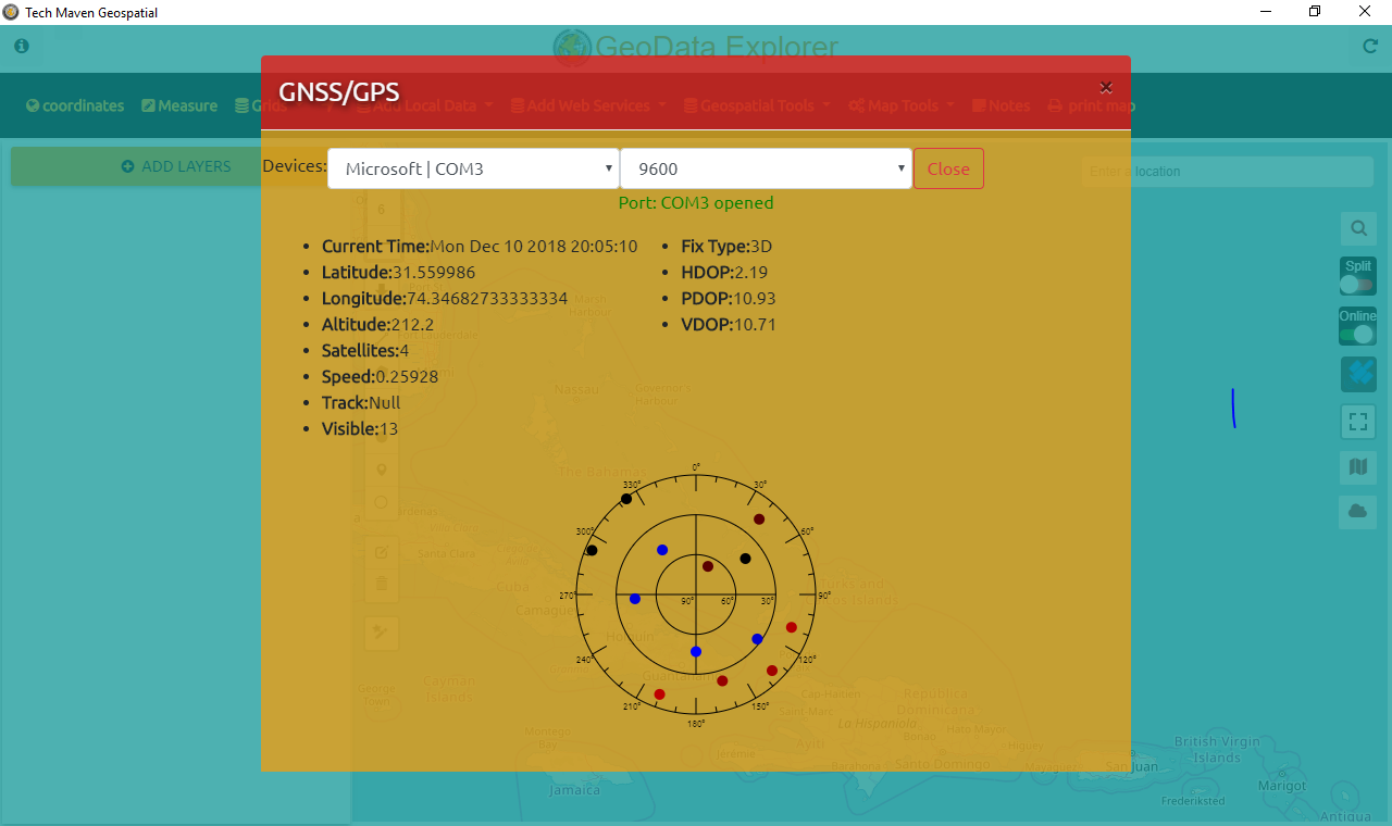
Support for high precision external Bluetooth GPS / GNSS Receivers
Take your survey and mapping and GIS data visualization and data capture to the next level with submeter sub-foot and centimeter (RTK) positions via external Bluetooth, Serial, USB GNSS Receivers (GPS Global Positioning Systems). You can even work with Real-Time Networks (RTN) Continous Operating Reference Receivers and other services for position corrections.
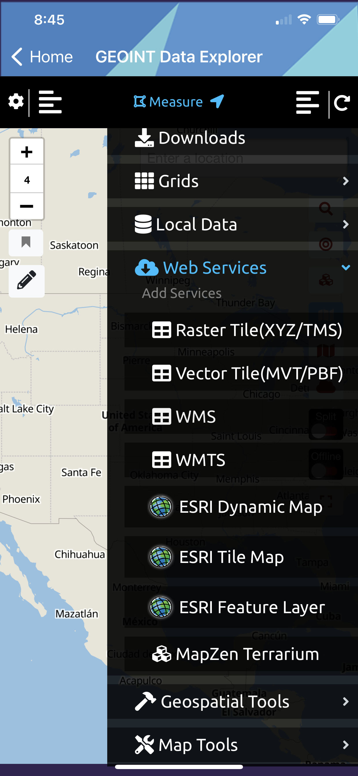
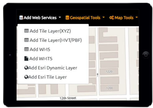
Connect to Web Mapping Services
Connect to OGC and ESRI Mapping Services
Measure Length and Area
Measure Tools allow you to measure complex linear/lines and area/polygon measurements.
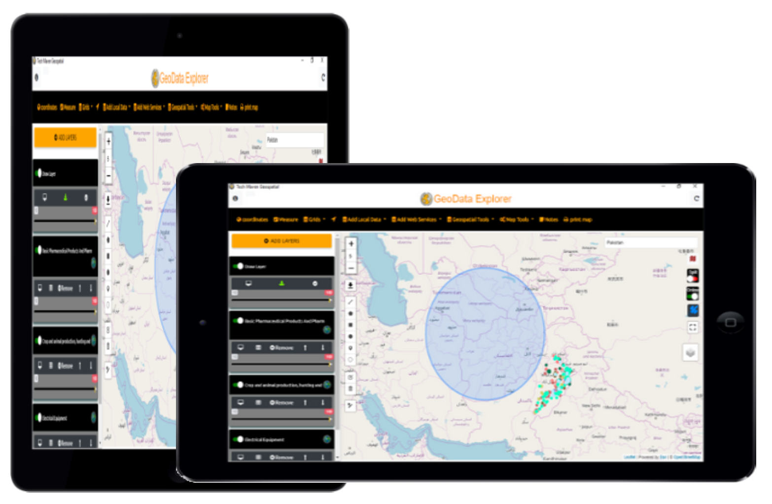
Works Landscape or Portrait Mode
Responsive design that’s flexible to enable you to work landscape or portrait and any screen size/resolution/pixel density Table of Contents Collapses and Top Menu becomes side menu as needed
Configure styling of vector data
JSON Catalog Files and Catalog Editor
Adjust Transparency
Each layer has an Opacity Control.
Supported Formats:
| Files | Services |
|---|---|
| Raster Tiles | OGC WMTS -TILES |
| GPKG Raster Tiles * Not in Lite Ver | OGC WMS |
| MBTiles Raster Tiles * Not in Lite Ver | Raster Tile Server (XYZ/TMS) |
| Vector | Vector Tile Server (MVT/PBF) XYZ |
| MBTiles Vector Tiles * Not in Lite Ver | ESRI ArcGIS Dynamic Map Services (MapServer) |
| ESRI Shapefile | ESRI ArcGIS FeatureServer Layer |
| GeoJSON | |
| OGC GPKG - GeoPackage Vector Features * Not in Lite Ver | GeoTagged Photos JPG |
| KMZ/KML | WFS - Future |
| TEXT -TSV, CSV | CSW/CKAN -future |
| Offline Elevation Tiles for Spot Elevation and Terrain Profile View Graph from MBTILES in MapZen Terrarium Spec PNG. * Not in Lite Ver | |
| OSM Vector Tiles MBTILES * Not in Lite Ver | WPS -future |
Perfect for use in an office environment, in a vehicle or in the field you’ve got a fully equipped easy to use GIS that has the capabilities you need.
Feature Tour
Mapping Web Services

Global Area Reference System Grid
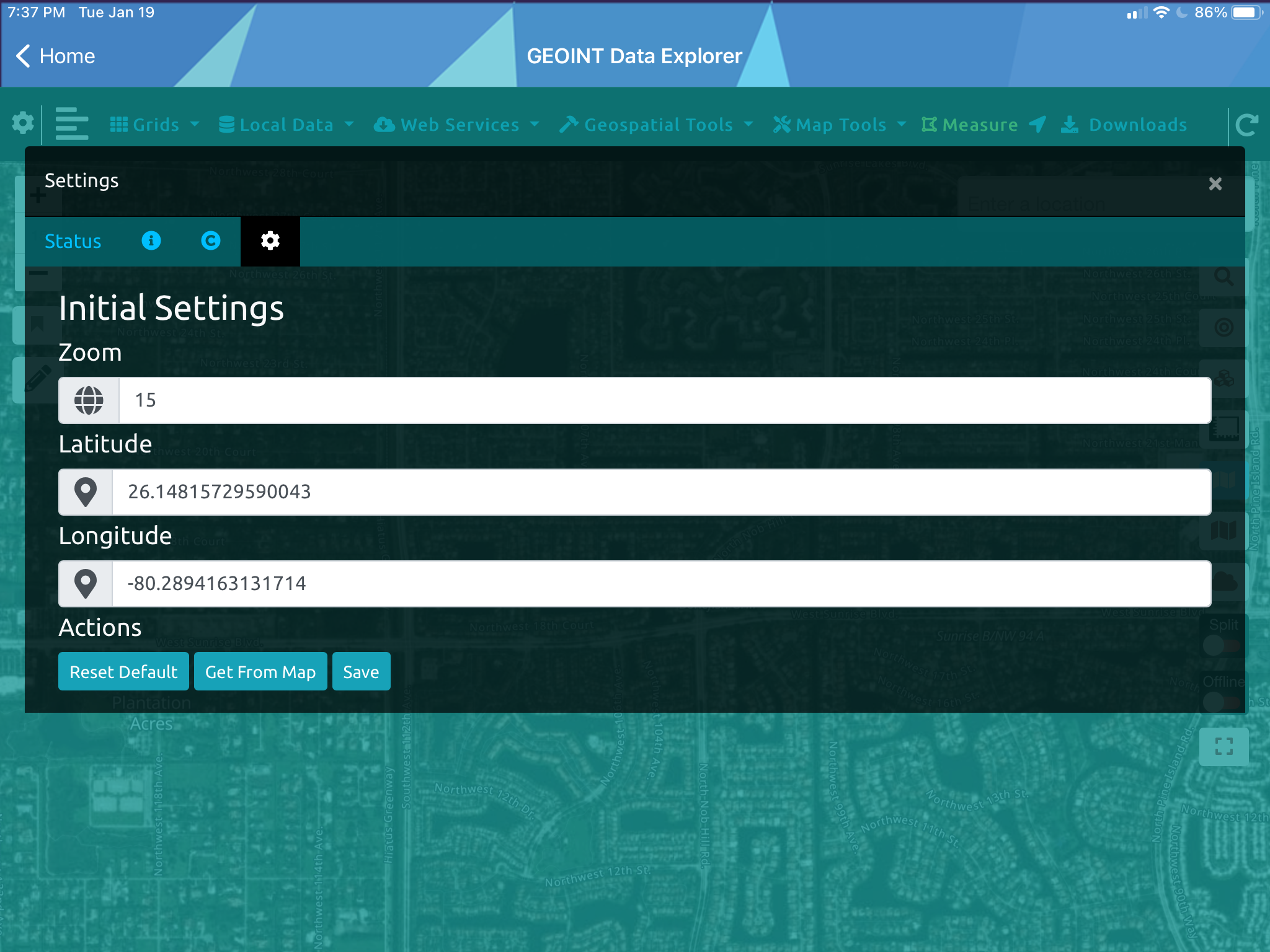
Initial map settings
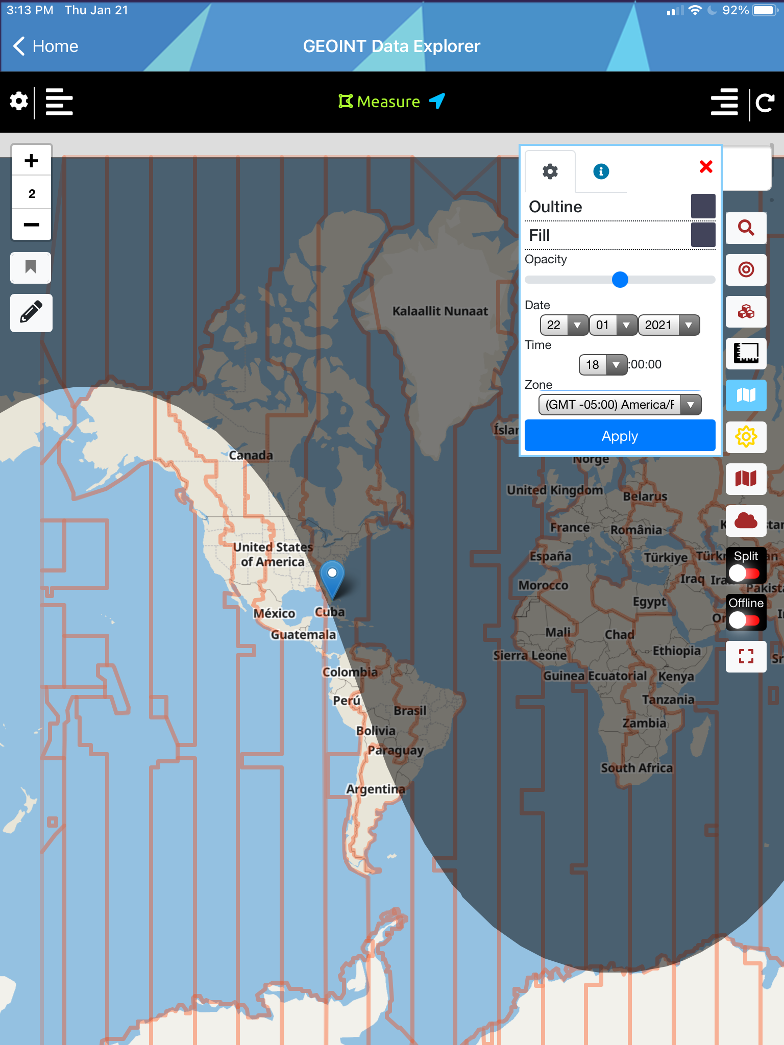
Day-Night Regions & Time Zones
OGC GPKG GeoPackage Vector Features

Place Search and Geocoding and Directions

ESRI ArcGIS ImageServices
ESRI ArcGIS Server FeatureServer Layer
Search Loaded Data
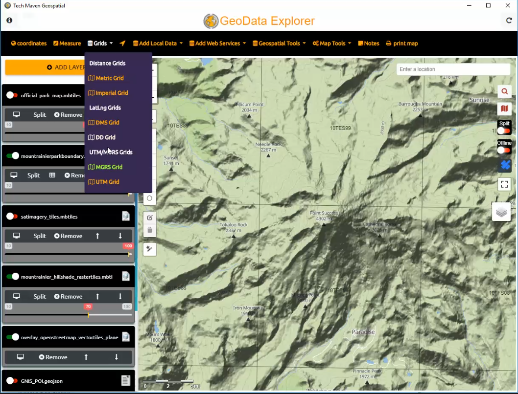
Display Grids
Style Data and Mouse Over info
Adjust Opacity

JSON Catalog
Label Features
Screen Size and Orientation

Overview MiniMap
Local Data

Swipe Compare
Tiling of vector data
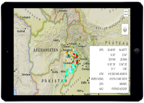
Coordinates
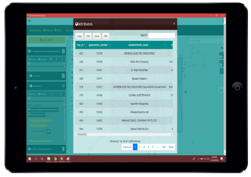
Attribute Table and Export
GeoTag Photos
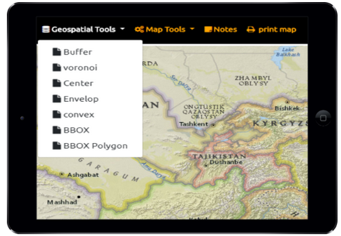
Geospatial Analysis
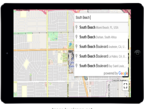
Place Search and Geocoding and Directions
Spatial Bookmarks
Web Services Data
Measure Tools

Basemap Picker

CSV Text File
OSM Vector Tiles

Vector Tile Server URL (.MVT/.PBF)
Geolocation and GNSS Settings

Raster Tile Server (XYZ or TMS)
ESRI Shapefile
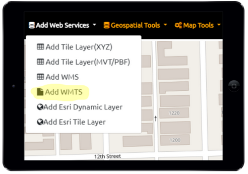
Web Map Tile Service (WMTS)
ESRI Dynamic Map Services
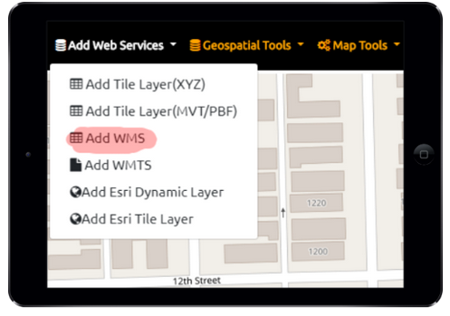
Web Map Service (WMS)

GeoPackage Features
View Offline Vector Tiles
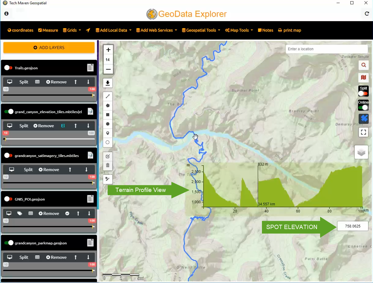
View Spot Elevation and Terrain Profile View

View Offline Raster Tiles (MBTILES/GPKG)
Map Annotation
Collect Feature Data
Who is GeoData Explorer app for?
Everyone!
Government Agencies
Any level of Government tons of uses for the app.
Utilities
Electric, Fiber Optic, Cable, Phone, Water and Wastewater, Natural Gas offline mapping and access to OGC and ESRI Mapping Services make it perfect for utility agencies.
Emergency Management
Rescue and Recovery Damage Assessments Coordination and Planning
Architecture, Engineering, Construction, Planning, Surveying and Mapping
AEC, Lanscape Architecture, Planning
Survey and Mapping
Real Property and Facility Asset Management
Asset management and mapping
Land Development
Property Appraiser
Commercial Developer
Real Estate Appraiser
Environmental Natural Resources
Monitor environmental conditions, manage resources and assets, perform analysis and print ready maps
Community Health Services
Defense and Intelligence
Homeland Security
Law Enforcement
Agriculture
Perfect for your precision managed Agriculture and large farms.
Use the drawing tool and feature creation to tag information about locations.
View color panchromatic imagery and near infrared from many web services
NGO's
Humanitarian, Relief and Support and Non Government Organizations
mapping is crucial for effective operations
GeoData Explorer is an innovative application developed with passion and commitment by Tech Maven Geospatial, LLC
Please check out our other apps and services we offer. Portfolio
Supported Operating Systems
GeoData Explorer versions of Operating Systems Supported:
Android versions supported API Level 19 (4.4 Kit Kat) to 27 (9 Pie)
We’ve extensively tested it on Marshmellow 6.0 Nougat 7.0 and Oreo 8.0
Windows 10 (all versions) from Microsoft Store APPX.
If you have other versions of Windows you need to support like Windows 7 we can sell you a Windows Desktop EXE.
We can also provide MSI distributions for Enterprises.
iOS iPAD version 13 and 14 are supported
On special requests, we can also build Mac OSX versions and Linux versions for Ubuntu Desktop, Lubuntu Desktop and other flavors
Notes about Screen Shots and Videos
We make every attempt to update the website as the User Interface Changes/Improves in the App.
Note: Some screenshots and videos may reflect differently than the actual app.
Ready to get started?
Download the app from your app store or contact us for custom builds and versions. For Windows, we have Windows MSI and EXE builds in addition to the Windows Store APPX
We would love to hear from you
Please feel free to suggest features, enhancements, ideas or data to include
Features Coming Soon:
Tech Maven Geospatial is actively developing and supporting this app and has a large Roadmap of additional features and capabilities will be developed. We also encourage you to send us feedback.
planned future features are:
We make no promise or commitment to have these features available by any time, however, we have a large list of new features and enhancements logged in our application lifecycle management system
- Sync’d view to 3D Terrain
- Reproject Vector Data that’s NOT in Geographic WGS84 and possibly support unzipped shp and filegdb
- GL JSON Styling Tool and Load your own vector tile stylesheet
- Support for ESRI FeatureServer Layers
- Support for ESRI Layer Package (LPK) vector format from ArcMap
- Integration with Open Street Map (OSM) Overpass API
- Integration with other online services for Points of Interest and Location Data: FourSquare API
- Street Level Photo from Bing, Google and Mappilary
- Recent Satellite Photos from Digital Globe, Planet and ESA Sentinal and Others
- Orthophoto-Aerials, Obliques and other data from NearMap and Geomni
- Additional data visualizations like heatmaps, hexabins, marker clustering and other
- Options to have richer forms with preconfigured settings for field names and data types
- GeoFencing with Alerts/Notifications
- Range Rings and other distance calculations
- Social Location Sharing
- Enhanced Field Data Collection and Observation Reporting to Server with dashboard
- Request an Area of Interest for offline GeoPackage or MBTiles for Raster and Vector Data.
- Support for additional file types and data formats like ESRI BIL Terrain/Elevation,Better GeoTIFF support, JPG2000 and MrSID raster imagery, JSON/GeoJSON Tiled online and offline data, XYZ/TMS Raster/Vector/Elevation Tiles in Zip file option for offline data.
- Integration into OGC Web Feature Service -WFS
- GeoServer REST API
- Additional CSV/TSV Mapping with predefined fields for regions of geography (Country, Region, State, Province, Zipcode, City, MSA, Census Tract, Census Block Group, Census Block, TTRRSS and many others) for rapid matching of attribute data to a location
- Other Routing and Search services
- Additional Analysis features and functionality like Point in Polygon and intersection
- Additional Export features like OGC GPKG, SHP.
- Showing Night and Day, TimeZones and other references data
and Much Much More…..
We also develop custom apps and solutions and consulting, project management and systems architecture and geospatial data services like map tiling and data conversion. Please contact us regarding your requirements.
Field Data Collection
If you are looking for an application that’s more centered around form based field data collection surveys please check out our sister app Orange Maps Collector/GeoData Collector